Aerial Imaging Market Size, Share & Trends Analysis Report by Platform (Manned Aircraft, Unmanned Aerial Vehicles (UAVs/Drones), Satellites, Lighter-Than-Air (LTA) Platforms), Imaging Type, Data Type, Application, End-Use Industry, and Geography (North America, Europe, Asia Pacific, Middle East, Africa, and South America) – Global Industry Data, Trends, and Forecasts, 2026–2035
Aerial Imaging Market Summary:
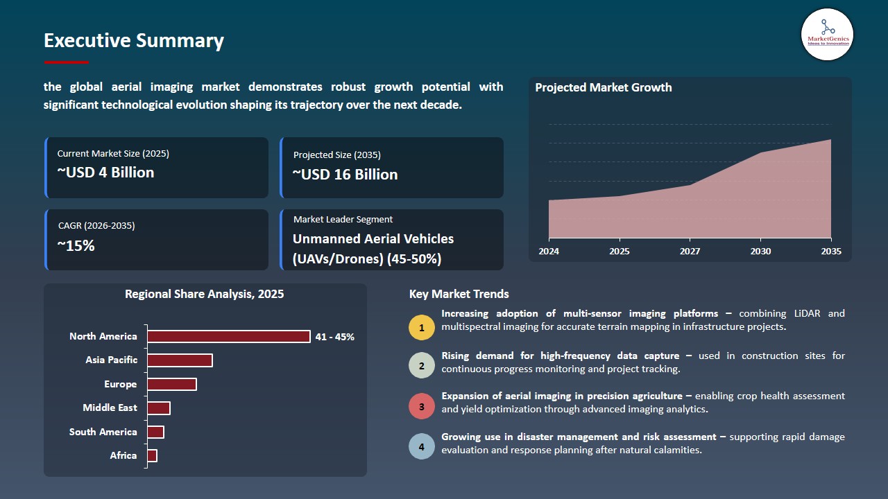
The global aerial imaging market is witnessing strong growth, valued at USD 3.9 billion in 2025 and projected to reach USD 16.1 billion by 2035, expanding at a CAGR of 15.2% during the forecast period.
|
|
|
Segmental Data Insights |
|
|
Demand Trends |
|
|
Competitive Landscape |
|
|
Strategic Development |
|
|
Future Outlook & Opportunities |
|
Aerial-Imaging-Market Size, Share, and Growth
Aerial imaging platform is shifting from remote sensing to real-time geospatial intelligence layers, where UAVs, satellites and AI-enabled imaging systems are generating and processing spatial data in real-time to support automated mapping and monitoring, as well as informed decision-making.
Peter Wilczynski, Chief Product Officer at Maxar Intelligence, said: By eliminating reliance on GPS, Raptor software unlocks the full potential of autonomous systems from powering truly joint multi-domain operations as part of a digital battlefield to large-scale delivery systems in urban areas where knowing the precise coordinates of your drop-off location is critical to getting the job done. Raptor will change the game for customers across the defense and commercial sectors. This software uses Maxar’s unique 3D global terrain data to ensure that autonomous systems get the job done no matter how much GPS interference they face.
Aerial-Survey-Market is evolving from conventional aerial photography into a persistently connected geospatial intelligence system, where UAVs, satellites and AI-driven analytical platforms work in unison to provide real-time geospatial intelligence for dynamic decision-making applications. The growing adoption of persistent Earth observation is turning aerial imaging into a real-time data platform for predictive insights instead of periodic mapping services for defense, infrastructure and environmental monitoring.
Aerial imaging systems are also evolving towards autonomous perception platforms, where aerial sensors are integrated with edge AI to perceive and interpret changes affecting the terrain, detect anomalies, and update spatial models on-the-fly rather than relying on extensive data processing in the back room. This is facilitating dynamic mapping in rapidly evolving environments like disaster zones, urban growth zones and major infrastructure projects where spatial realignment is needed to ensure operational accuracy including advanced drone mapping capabilities.
An adjacent opportunity lies in the convergence of aerial imaging with autonomous mobility networks and digital twin ecosystems, where continuously updated geospatial imagery data is used to simulate real-world environments, optimize logistics pathways, and enable synchronized decision-making across distributed systems, ultimately creating self-evolving spatial intelligence frameworks for next-generation industrial and environmental applications.
Aerial Imaging market Dynamics and Trends
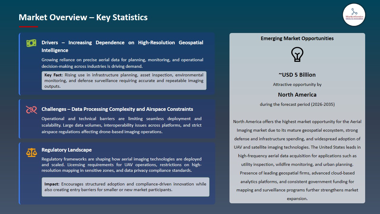
Driver: Rising demand for geospatial intelligence and real-time mapping
- The global aerial imaging market is growing because of the increasing need for high-resolution geospatial intelligence in infrastructure management, security and surveillance monitoring, and environmental monitoring, where real-time geospatial information is required to provide timely and informed decision making through remote sensing technologies.
- Government and commercial interests are embracing satellite-based Earth observation systems; for instance, in March 2025, the Mohammed Bin Rashid Space Centre (MBRSC) launched the first SAR-based Earth observation satellite with Satrec Initiative, called Etihad-SAT, for high-resolution all-weather imagery for real-time mapping, environmental assessment, and infrastructure monitoring.
- The need for continuous earth observation and simulation and predictive mapping is driving the use of integrated UAV and satellite imaging solutions for large-scale monitoring.
Restraint: High operational and data processing complexity
- The global aerial imaging market is limited by the rapidly expanding flow of high-resolution geospatial data from UAVs and satellites, which demands high-performance computing for real-time data processing, AI-powered processing engines and high-bandwidth cloud computing for storage and processing using surveying drones. .
- Integration of multi-source aerial data streams (e.g. optical, LiDAR, thermal) for processing, analysis and knowledge extraction requires ongoing calibration and synchronization of data streams making system deployment and scalability complex in different environmental settings.
- Incompatibility and lack of interoperability among systems is hampering integration and widespread deployment.
Opportunity: Expansion of AI-enabled autonomous aerial systems
- The Aerial Imaging market is witnessing strong growth potential due to rapid deployment of AI-enabled autonomous UAV and satellite systems, enabling real-time spatial data capture and high-precision monitoring across defense, infrastructure, and industrial applications.
- UAV and satellite systems are increasingly becoming multi-sensor, AI-enabled systems that improve autonomous flight, perception and decision-making capabilities in real-world scenarios; for instance, in January 2026, GDU released the UAV-P300 AI-powered UAV system with LiDAR, visual SLAM, and AI-based obstacle avoidance for autonomous flight and real-time aerial imaging and high-precision inspection in smart city and industrial applications.
- This growth is driving the use of integrated AI-driven Aerial Intelligence solutions for monitoring and situational awareness.
Key Trend: Shift toward AI-integrated UAV and satellite imaging ecosystems
- The aerial imaging market is transitioning to fully integrate AI-enabled geospatial ecosystems that fuse UAVs, satellites and cloud-based analytics platforms to support continuous real-time mapping, automated feature recognition and dynamic spatial intelligence creation for large-scale mapping applications.
- The ecosystem is evolving with the help of AI-enabled data fusion platforms that integrate aerial, orbital and terrestrial data to deliver improved accuracy, automation and forecasting for geospatial intelligence in defense, urban and environmental monitoring systems.
- This is enabling perpetual multi-platform learning across imaging platforms to enhance mapping accuracy, anomaly recognition and autonomous decision-making capabilities in global Aerial Intelligence Networks.
Aerial Imaging Market Analysis and Segmental Data
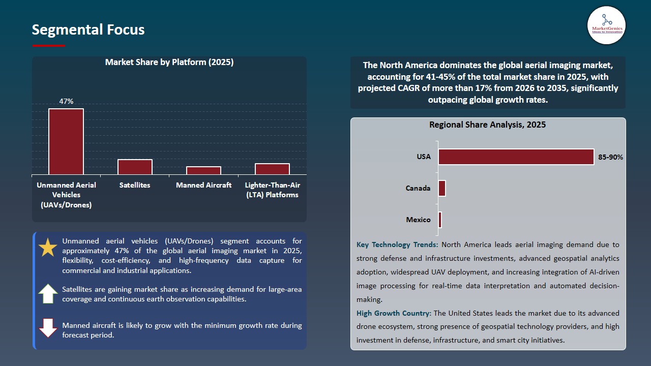
Unmanned Aerial Vehicles (UAVs/Drones) Dominate Global Aerial Imaging Market
- UAVs and drone platforms dominate the aerial imaging market due to their ability to capture high-resolution geospatial data, enable rapid area scanning, and deliver real-time visual intelligence across defense, infrastructure, and commercial applications in complex environments.
- Organizations are accelerating the use of AI-powered autonomous UAVs for real-time mapping, inspection, and surveillance; for instance, in March 2026, Lantronix and Unusual Machines have partnered to build NDAA-compliant, AI-powered autonomous components for drones, that combine edge AI and flight control, enabling real-time perception, navigation, and high-precision aerial imaging for use in U.S. defense operations.
- UAV imaging systems are increasingly important to provide situational awareness, efficiency, and rapid decision-making for large-scale inspection and surveillance.
North America Leads Global Aerial Imaging Market Demand
- North America is emerging as the leading region in the aerial imaging market due to strong UAV mapping deployment, advanced satellite imaging systems, and high adoption of AI-driven geospatial analytics across defense, infrastructure, and commercial sectors.
- Increasing integration of drone imaging and spatial intelligence is taking place in the region; for example, in April 2026, NASA signed a contract with UNOS to explore the use of drone-based aerial imaging for the transport of organs, allowing real-time monitoring, and route planning, and enhanced UAV efficiency in time-sensitive transport operations in North America.
- Continued investment in geospatial intelligence systems and cloud-based analytics capabilities for aerial imaging also contribute to North America's position as an aerial imaging innovator.
Aerial Imaging Market Ecosystem
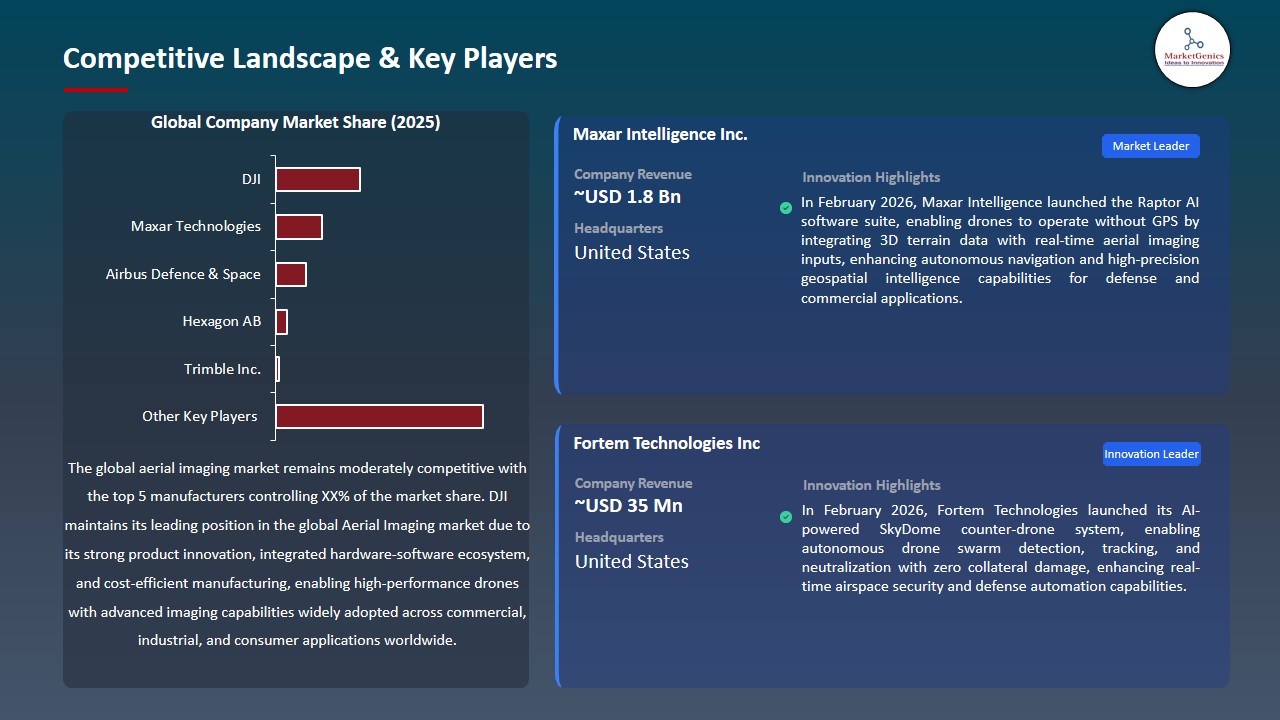
The global aerial imaging market is moderately consolidated and is driven by the rapid growth of geospatial intelligence systems, growing demand of UAV-based imaging systems, and the rising integration of AI-powered mapping and analytics systems across defense, infrastructure, agriculture and smart cities. The leading players including DJI, Maxar Technologies, Airbus Defence & Space, Hexagon AB, and Trimble Inc. are constantly innovating in aerial imaging technologies through high-resolution sensors, satellite imaging, and AI-driven geospatial data intelligence platforms to deliver real-time spatial intelligence and actionable insights.
DJI dominates the commercial UAV imaging landscape with innovative drone systems equipped with high-resolution cameras, LiDAR sensors, and intelligent flight controls, providing accurate aerial mapping, inspection and real-time data collection for industrial and commercial use cases. Maxar Technologies offers high-resolution satellite and aerial imaging technologies integrated with AI-powered geospatial intelligence platforms for defense, disaster management and large-scale terrain mapping.
Airbus Defence & Space offers cutting-edge geospatial and aerial imaging solutions with satellite constellations and remote sensing technologies, providing precise and continuous monitoring of environmental, security and infrastructure assets. Hexagon AB offers geospatial intelligence solutions that combine aerial imaging, digital twin and AI-based analytics to enable smart urban development, industrial asset management, and autonomous mapping.
Trimble Inc. is dedicated to the integration of aerial imaging, positioning technologies, GPS and cloud-based geospatial intelligence services to support precision mapping, construction management, and farm management. The integration of UAV imaging, satellite intelligence and AI-driven analytics, Aerial Imaging is transforming into a real-time geo-spatial intelligence ecosystem that improves operational efficiency, situational understanding and analytics-based decision-making in global industries.
Recent Development and Strategic Overview
- In February 2026, Fortem Technologies launched its AI-powered SkyDome counter-drone system, enabling autonomous drone swarm detection, tracking, and neutralization with zero collateral damage, enhancing real-time airspace security and defense automation capabilities.
- In February 2025, Maxar Intelligence launched the Raptor AI software suite, enabling drones to operate without GPS by integrating 3D terrain data with real-time aerial imaging inputs, enhancing autonomous navigation and high-precision geospatial intelligence capabilities for defense and commercial applications.
Report Scope
|
Detail |
|
|
Market Size in 2025 |
USD 3.9 Bn |
|
Market Forecast Value in 2035 |
USD 16.1 Bn |
|
Growth Rate (CAGR) |
15.2% |
|
Forecast Period |
2026 – 2035 |
|
Historical Data Available for |
2021 – 2024 |
|
Market Size Units |
US$ Billion for Value Thousand Units for Volume |
|
Report Format |
Electronic (PDF) + Excel |
|
North America |
Europe |
Asia Pacific |
Middle East |
Africa |
South America |
|
|
|
|
|
|
|
Companies Covered |
|||||
|
|
|
|
|
|
Aerial Imaging Market Segmentation and Highlights
|
Segment |
Sub-segment |
|
Aerial Imaging Market, By Platform |
|
|
Aerial Imaging Market, By Imaging Type |
|
|
Aerial Imaging Market, By Data Type |
|
|
Aerial Imaging Market, By Application |
|
|
Aerial Imaging Market, By End-Use Industry |
|
Frequently Asked Questions
Table of Contents
- 1. Research Methodology and Assumptions
- 1.1. Definitions
- 1.2. Research Design and Approach
- 1.3. Data Collection Methods
- 1.4. Base Estimates and Calculations
- 1.5. Forecasting Models
- 1.5.1. Key Forecast Factors & Impact Analysis
- 1.6. Secondary Research
- 1.6.1. Open Sources
- 1.6.2. Paid Databases
- 1.6.3. Associations
- 1.7. Primary Research
- 1.7.1. Primary Sources
- 1.7.2. Primary Interviews with Stakeholders across Ecosystem
- 2. Executive Summary
- 2.1. Global Aerial Imaging Market Outlook
- 2.1.1. Aerial Imaging Market Size (Volume - Thousand Units & Value - US$ Bn), and Forecasts, 2021-2035
- 2.1.2. Compounded Annual Growth Rate Analysis
- 2.1.3. Growth Opportunity Analysis
- 2.1.4. Segmental Share Analysis
- 2.1.5. Geographical Share Analysis
- 2.2. Market Analysis and Facts
- 2.3. Supply-Demand Analysis
- 2.4. Competitive Benchmarking
- 2.5. Go-to- Market Strategy
- 2.5.1. Customer/ End-use Industry Assessment
- 2.5.2. Growth Opportunity Data, 2026-2035
- 2.5.2.1. Regional Data
- 2.5.2.2. Country Data
- 2.5.2.3. Segmental Data
- 2.5.3. Identification of Potential Market Spaces
- 2.5.4. GAP Analysis
- 2.5.5. Potential Attractive Price Points
- 2.5.6. Prevailing Market Risks & Challenges
- 2.5.7. Preferred Sales & Marketing Strategies
- 2.5.8. Key Recommendations and Analysis
- 2.5.9. A Way Forward
- 2.1. Global Aerial Imaging Market Outlook
- 3. Industry Data and Premium Insights
- 3.1. Global Semiconductors & Electronics Industry Overview, 2025
- 3.1.1. Semiconductors & Electronics Industry Ecosystem Analysis
- 3.1.2. Key Trends for Semiconductors & Electronics Industry
- 3.1.3. Regional Distribution for Semiconductors & Electronics Industry
- 3.2. Supplier Customer Data
- 3.3. Technology Roadmap and Developments
- 3.4. Trade Analysis
- 3.4.1. Import & Export Analysis, 2025
- 3.4.2. Top Importing Countries
- 3.4.3. Top Exporting Countries
- 3.5. Trump Tariff Impact Analysis
- 3.5.1. Manufacturer
- 3.5.1.1. Based on the component & Raw material
- 3.5.2. Supply Chain
- 3.5.3. End Consumer
- 3.5.1. Manufacturer
- 3.6. Raw Material Analysis
- 3.1. Global Semiconductors & Electronics Industry Overview, 2025
- 4. Market Overview
- 4.1. Market Dynamics
- 4.1.1. Drivers
- 4.1.1.1. Rising demand for geospatial intelligence and real-time mapping across defense, infrastructure, and environmental monitoring applications
- 4.1.1.2. Increasing adoption of UAVs, satellites, and AI-powered imaging systems for high-precision spatial data collection and analysis
- 4.1.1.3. Growing use of aerial imaging in smart city development, disaster management, and precision agriculture applications
- 4.1.2. Restraints
- 4.1.2.1. High cost of advanced UAV systems, satellite infrastructure, and data analytics platforms limiting adoption
- 4.1.2.2. Data processing complexity and lack of standardized geospatial data formats affecting large-scale integration and interoperability
- 4.1.1. Drivers
- 4.2. Key Trend Analysis
- 4.3. Regulatory Framework
- 4.3.1. Key Regulations, Norms, and Subsidies, by Key Countries
- 4.3.2. Tariffs and Standards
- 4.3.3. Impact Analysis of Regulations on the Market
- 4.4. Value Chain Analysis
- 4.5. Porter’s Five Forces Analysis
- 4.6. PESTEL Analysis
- 4.7. Global Aerial Imaging Market Demand
- 4.7.1. Historical Market Size – Volume (Thousand Units) & Value (US$ Bn), 2020-2024
- 4.7.2. Current and Future Market Size – Volume (Thousand Units) & Value (US$ Bn), 2026–2035
- 4.7.2.1. Y-o-Y Growth Trends
- 4.7.2.2. Absolute $ Opportunity Assessment
- 4.1. Market Dynamics
- 5. Competition Landscape
- 5.1. Competition structure
- 5.1.1. Fragmented v/s consolidated
- 5.2. Company Share Analysis, 2025
- 5.2.1. Global Company Market Share
- 5.2.2. By Region
- 5.2.2.1. North America
- 5.2.2.2. Europe
- 5.2.2.3. Asia Pacific
- 5.2.2.4. Middle East
- 5.2.2.5. Africa
- 5.2.2.6. South America
- 5.3. Product Comparison Matrix
- 5.3.1. Specifications
- 5.3.2. Market Positioning
- 5.3.3. Pricing
- 5.1. Competition structure
- 6. Global Aerial Imaging Market Analysis, by Platform
- 6.1. Key Segment Analysis
- 6.2. Aerial Imaging Market Size (Volume - Thousand Units & Value - US$ Bn), Analysis, and Forecasts, by Platform, 2021-2035
- 6.2.1. Manned Aircraft
- 6.2.1.1. Fixed-Wing Aircraft
- 6.2.1.2. Helicopters
- 6.2.1.3. Gyrocopters
- 6.2.1.4. Others
- 6.2.2. Unmanned Aerial Vehicles (UAVs/Drones)
- 6.2.2.1. Fixed-Wing Drones
- 6.2.2.2. Multi-Rotor Drones
- 6.2.2.3. Hybrid VTOL Drones
- 6.2.2.4. Others
- 6.2.3. Satellites
- 6.2.3.1. Low Earth Orbit (LEO) Satellites
- 6.2.3.2. Medium Earth Orbit (MEO) Satellites
- 6.2.3.3. Geostationary (GEO) Satellites
- 6.2.3.4. Others
- 6.2.4. Lighter-Than-Air (LTA) Platforms
- 6.2.4.1. Aerostats
- 6.2.4.2. Blimps & Balloons
- 6.2.4.3. Others
- 6.2.1. Manned Aircraft
- 7. Global Aerial Imaging Market Analysis, by Imaging Type
- 7.1. Key Segment Analysis
- 7.2. Aerial Imaging Market Size (Volume - Thousand Units & Value - US$ Bn), Analysis, and Forecasts, by Imaging Type, 2021-2035
- 7.2.1. Optical/Electro-Optical (EO) Sensors
- 7.2.1.1. Multispectral Sensors
- 7.2.1.2. Hyperspectral Sensors
- 7.2.1.3. RGB/True Color Sensors
- 7.2.1.4. Others
- 7.2.2. Infrared (IR) Sensors
- 7.2.2.1. Near-Infrared (NIR)
- 7.2.2.2. Thermal Infrared (TIR)
- 7.2.2.3. Short-Wave Infrared (SWIR)
- 7.2.3. Synthetic Aperture Radar (SAR)
- 7.2.3.1. X-Band SAR
- 7.2.3.2. C-Band SAR
- 7.2.3.3. L-Band SAR
- 7.2.3.4. Others
- 7.2.4. LiDAR (Light Detection and Ranging)
- 7.2.4.1. Topographic LiDAR
- 7.2.4.2. Bathymetric LiDAR
- 7.2.5. Combination/Hybrid Sensors
- 7.2.1. Optical/Electro-Optical (EO) Sensors
- 8. Global Aerial Imaging Market Analysis, by Data Type
- 8.1. Key Segment Analysis
- 8.2. Aerial Imaging Market Size (Volume - Thousand Units & Value - US$ Bn), Analysis, and Forecasts, by Data Type, 2021-2035
- 8.2.1. 2D Aerial Imagery
- 8.2.2. 3D Modeling & Point Cloud
- 8.2.3. Orthomosaics
- 8.2.4. Digital Elevation Models (DEM)
- 8.2.5. Digital Surface Models (DSM)
- 8.2.6. Digital Terrain Models (DTM)
- 8.2.7. Thermal Maps
- 8.2.8. Spectral Index Maps
- 8.2.9. Others
- 9. Global Aerial Imaging Market Analysis, by Application
- 9.1. Key Segment Analysis
- 9.2. Aerial Imaging Market Size (Volume - Thousand Units & Value - US$ Bn), Analysis, and Forecasts, by Application, 2021-2035
- 9.2.1. Surveying & Mapping
- 9.2.2. Urban Planning & Infrastructure Development
- 9.2.3. Environmental Monitoring & Conservation
- 9.2.4. Precision Agriculture & Crop Health Monitoring
- 9.2.5. Disaster Management & Emergency Response
- 9.2.6. Oil, Gas & Pipeline Monitoring
- 9.2.7. Mining & Quarrying Surveys
- 9.2.8. Forestry Management
- 9.2.9. Coastal & Maritime Surveillance
- 9.2.10. Defense, Intelligence & Security Surveillance
- 9.2.11. Real Estate & Construction Monitoring
- 9.2.12. Transportation & Traffic Management
- 9.2.13. Archaeology & Cultural Heritage Documentation
- 9.2.14. Insurance Risk Assessment
- 9.2.15. Others
- 10. Global Aerial Imaging Market Analysis, by End-Use Industry
- 10.1. Key Segment Analysis
- 10.2. Aerial Imaging Market Size (Volume - Thousand Units & Value - US$ Bn), Analysis, and Forecasts, by End-Use Industry, 2021-2035
- 10.2.1. Agriculture & Forestry
- 10.2.2. Defense & National Security
- 10.2.3. Government & Public Administration
- 10.2.4. Energy & Utilities
- 10.2.5. Construction & Real Estate
- 10.2.6. Mining & Natural Resources
- 10.2.7. Environmental & Conservation Agencies
- 10.2.8. Transportation & Logistics
- 10.2.9. Telecommunications
- 10.2.10. Archaeology & Cultural Heritage
- 10.2.11. Media & Entertainment
- 10.2.12. Others
- 11. Global Aerial Imaging Market Analysis and Forecasts, by Region
- 11.1. Key Findings
- 11.2. Aerial Imaging Market Size (Volume - Thousand Units & Value - US$ Bn), Analysis, and Forecasts, by Region, 2021-2035
- 11.2.1. North America
- 11.2.2. Europe
- 11.2.3. Asia Pacific
- 11.2.4. Middle East
- 11.2.5. Africa
- 11.2.6. South America
- 12. North America Aerial Imaging Market Analysis
- 12.1. Key Segment Analysis
- 12.2. Regional Snapshot
- 12.3. North America Aerial Imaging Market Size (Volume - Thousand Units & Value - US$ Bn), Analysis, and Forecasts, 2021-2035
- 12.3.1. Platform
- 12.3.2. Imaging Type
- 12.3.3. Data Type
- 12.3.4. Application
- 12.3.5. End-Use Industry
- 12.3.6. Country
- 12.3.6.1. USA
- 12.3.6.2. Canada
- 12.3.6.3. Mexico
- 12.4. USA Aerial Imaging Market
- 12.4.1. Country Segmental Analysis
- 12.4.2. Platform
- 12.4.3. Imaging Type
- 12.4.4. Data Type
- 12.4.5. Application
- 12.4.6. End-Use Industry
- 12.5. Canada Aerial Imaging Market
- 12.5.1. Country Segmental Analysis
- 12.5.2. Platform
- 12.5.3. Imaging Type
- 12.5.4. Data Type
- 12.5.5. Application
- 12.5.6. End-Use Industry
- 12.6. Mexico Aerial Imaging Market
- 12.6.1. Country Segmental Analysis
- 12.6.2. Platform
- 12.6.3. Imaging Type
- 12.6.4. Data Type
- 12.6.5. Application
- 12.6.6. End-Use Industry
- 13. Europe Aerial Imaging Market Analysis
- 13.1. Key Segment Analysis
- 13.2. Regional Snapshot
- 13.3. Europe Aerial Imaging Market Size (Volume - Thousand Units & Value - US$ Bn), Analysis, and Forecasts, 2021-2035
- 13.3.1. Platform
- 13.3.2. Imaging Type
- 13.3.3. Data Type
- 13.3.4. Application
- 13.3.5. End-Use Industry
- 13.3.6. Country
- 13.3.6.1. Germany
- 13.3.6.2. United Kingdom
- 13.3.6.3. France
- 13.3.6.4. Italy
- 13.3.6.5. Spain
- 13.3.6.6. Netherlands
- 13.3.6.7. Nordic Countries
- 13.3.6.8. Poland
- 13.3.6.9. Russia & CIS
- 13.3.6.10. Rest of Europe
- 13.4. Germany Aerial Imaging Market
- 13.4.1. Country Segmental Analysis
- 13.4.2. Platform
- 13.4.3. Imaging Type
- 13.4.4. Data Type
- 13.4.5. Application
- 13.4.6. End-Use Industry
- 13.5. United Kingdom Aerial Imaging Market
- 13.5.1. Country Segmental Analysis
- 13.5.2. Platform
- 13.5.3. Imaging Type
- 13.5.4. Data Type
- 13.5.5. Application
- 13.5.6. End-Use Industry
- 13.6. France Aerial Imaging Market
- 13.6.1. Country Segmental Analysis
- 13.6.2. Platform
- 13.6.3. Imaging Type
- 13.6.4. Data Type
- 13.6.5. Application
- 13.6.6. End-Use Industry
- 13.7. Italy Aerial Imaging Market
- 13.7.1. Country Segmental Analysis
- 13.7.2. Platform
- 13.7.3. Imaging Type
- 13.7.4. Data Type
- 13.7.5. Application
- 13.7.6. End-Use Industry
- 13.8. Spain Aerial Imaging Market
- 13.8.1. Country Segmental Analysis
- 13.8.2. Platform
- 13.8.3. Imaging Type
- 13.8.4. Data Type
- 13.8.5. Application
- 13.8.6. End-Use Industry
- 13.9. Netherlands Aerial Imaging Market
- 13.9.1. Country Segmental Analysis
- 13.9.2. Platform
- 13.9.3. Imaging Type
- 13.9.4. Data Type
- 13.9.5. Application
- 13.9.6. End-Use Industry
- 13.10. Nordic Countries Aerial Imaging Market
- 13.10.1. Country Segmental Analysis
- 13.10.2. Platform
- 13.10.3. Imaging Type
- 13.10.4. Data Type
- 13.10.5. Application
- 13.10.6. End-Use Industry
- 13.11. Poland Aerial Imaging Market
- 13.11.1. Country Segmental Analysis
- 13.11.2. Platform
- 13.11.3. Imaging Type
- 13.11.4. Data Type
- 13.11.5. Application
- 13.11.6. End-Use Industry
- 13.12. Russia & CIS Aerial Imaging Market
- 13.12.1. Country Segmental Analysis
- 13.12.2. Platform
- 13.12.3. Imaging Type
- 13.12.4. Data Type
- 13.12.5. Application
- 13.12.6. End-Use Industry
- 13.13. Rest of Europe Aerial Imaging Market
- 13.13.1. Country Segmental Analysis
- 13.13.2. Platform
- 13.13.3. Imaging Type
- 13.13.4. Data Type
- 13.13.5. Application
- 13.13.6. End-Use Industry
- 14. Asia Pacific Aerial Imaging Market Analysis
- 14.1. Key Segment Analysis
- 14.2. Regional Snapshot
- 14.3. Asia Pacific Aerial Imaging Market Size (Volume - Thousand Units & Value - US$ Bn), Analysis, and Forecasts, 2021-2035
- 14.3.1. Platform
- 14.3.2. Imaging Type
- 14.3.3. Data Type
- 14.3.4. Application
- 14.3.5. End-Use Industry
- 14.3.6. Country
- 14.3.6.1. China
- 14.3.6.2. India
- 14.3.6.3. Japan
- 14.3.6.4. South Korea
- 14.3.6.5. Australia and New Zealand
- 14.3.6.6. Indonesia
- 14.3.6.7. Malaysia
- 14.3.6.8. Thailand
- 14.3.6.9. Vietnam
- 14.3.6.10. Rest of Asia Pacific
- 14.4. China Aerial Imaging Market
- 14.4.1. Country Segmental Analysis
- 14.4.2. Platform
- 14.4.3. Imaging Type
- 14.4.4. Data Type
- 14.4.5. Application
- 14.4.6. End-Use Industry
- 14.5. India Aerial Imaging Market
- 14.5.1. Country Segmental Analysis
- 14.5.2. Platform
- 14.5.3. Imaging Type
- 14.5.4. Data Type
- 14.5.5. Application
- 14.5.6. End-Use Industry
- 14.6. Japan Aerial Imaging Market
- 14.6.1. Country Segmental Analysis
- 14.6.2. Platform
- 14.6.3. Imaging Type
- 14.6.4. Data Type
- 14.6.5. Application
- 14.6.6. End-Use Industry
- 14.7. South Korea Aerial Imaging Market
- 14.7.1. Country Segmental Analysis
- 14.7.2. Platform
- 14.7.3. Imaging Type
- 14.7.4. Data Type
- 14.7.5. Application
- 14.7.6. End-Use Industry
- 14.8. Australia and New Zealand Aerial Imaging Market
- 14.8.1. Country Segmental Analysis
- 14.8.2. Platform
- 14.8.3. Imaging Type
- 14.8.4. Data Type
- 14.8.5. Application
- 14.8.6. End-Use Industry
- 14.9. Indonesia Aerial Imaging Market
- 14.9.1. Country Segmental Analysis
- 14.9.2. Platform
- 14.9.3. Imaging Type
- 14.9.4. Data Type
- 14.9.5. Application
- 14.9.6. End-Use Industry
- 14.10. Malaysia Aerial Imaging Market
- 14.10.1. Country Segmental Analysis
- 14.10.2. Platform
- 14.10.3. Imaging Type
- 14.10.4. Data Type
- 14.10.5. Application
- 14.10.6. End-Use Industry
- 14.11. Thailand Aerial Imaging Market
- 14.11.1. Country Segmental Analysis
- 14.11.2. Platform
- 14.11.3. Imaging Type
- 14.11.4. Data Type
- 14.11.5. Application
- 14.11.6. End-Use Industry
- 14.12. Vietnam Aerial Imaging Market
- 14.12.1. Country Segmental Analysis
- 14.12.2. Platform
- 14.12.3. Imaging Type
- 14.12.4. Data Type
- 14.12.5. Application
- 14.12.6. End-Use Industry
- 14.13. Rest of Asia Pacific Aerial Imaging Market
- 14.13.1. Country Segmental Analysis
- 14.13.2. Platform
- 14.13.3. Imaging Type
- 14.13.4. Data Type
- 14.13.5. Application
- 14.13.6. End-Use Industry
- 15. Middle East Aerial Imaging Market Analysis
- 15.1. Key Segment Analysis
- 15.2. Regional Snapshot
- 15.3. Middle East Aerial Imaging Market Size (Volume - Thousand Units & Value - US$ Bn), Analysis, and Forecasts, 2021-2035
- 15.3.1. Platform
- 15.3.2. Imaging Type
- 15.3.3. Data Type
- 15.3.4. Application
- 15.3.5. End-Use Industry
- 15.3.6. Country
- 15.3.6.1. Turkey
- 15.3.6.2. UAE
- 15.3.6.3. Saudi Arabia
- 15.3.6.4. Israel
- 15.3.6.5. Rest of Middle East
- 15.4. Turkey Aerial Imaging Market
- 15.4.1. Country Segmental Analysis
- 15.4.2. Platform
- 15.4.3. Imaging Type
- 15.4.4. Data Type
- 15.4.5. Application
- 15.4.6. End-Use Industry
- 15.5. UAE Aerial Imaging Market
- 15.5.1. Country Segmental Analysis
- 15.5.2. Platform
- 15.5.3. Imaging Type
- 15.5.4. Data Type
- 15.5.5. Application
- 15.5.6. End-Use Industry
- 15.6. Saudi Arabia Aerial Imaging Market
- 15.6.1. Country Segmental Analysis
- 15.6.2. Platform
- 15.6.3. Imaging Type
- 15.6.4. Data Type
- 15.6.5. Application
- 15.6.6. End-Use Industry
- 15.7. Israel Aerial Imaging Market
- 15.7.1. Country Segmental Analysis
- 15.7.2. Platform
- 15.7.3. Imaging Type
- 15.7.4. Data Type
- 15.7.5. Application
- 15.7.6. End-Use Industry
- 15.8. Rest of Middle East Aerial Imaging Market
- 15.8.1. Country Segmental Analysis
- 15.8.2. Platform
- 15.8.3. Imaging Type
- 15.8.4. Data Type
- 15.8.5. Application
- 15.8.6. End-Use Industry
- 16. Africa Aerial Imaging Market Analysis
- 16.1. Key Segment Analysis
- 16.2. Regional Snapshot
- 16.3. Africa Aerial Imaging Market Size (Volume - Thousand Units & Value - US$ Bn), Analysis, and Forecasts, 2021-2035
- 16.3.1. Platform
- 16.3.2. Imaging Type
- 16.3.3. Data Type
- 16.3.4. Application
- 16.3.5. End-Use Industry
- 16.3.6. Country
- 16.3.6.1. South Africa
- 16.3.6.2. Egypt
- 16.3.6.3. Nigeria
- 16.3.6.4. Algeria
- 16.3.6.5. Rest of Africa
- 16.4. South Africa Aerial Imaging Market
- 16.4.1. Country Segmental Analysis
- 16.4.2. Platform
- 16.4.3. Imaging Type
- 16.4.4. Data Type
- 16.4.5. Application
- 16.4.6. End-Use Industry
- 16.5. Egypt Aerial Imaging Market
- 16.5.1. Country Segmental Analysis
- 16.5.2. Platform
- 16.5.3. Imaging Type
- 16.5.4. Data Type
- 16.5.5. Application
- 16.5.6. End-Use Industry
- 16.6. Nigeria Aerial Imaging Market
- 16.6.1. Country Segmental Analysis
- 16.6.2. Platform
- 16.6.3. Imaging Type
- 16.6.4. Data Type
- 16.6.5. Application
- 16.6.6. End-Use Industry
- 16.7. Algeria Aerial Imaging Market
- 16.7.1. Country Segmental Analysis
- 16.7.2. Platform
- 16.7.3. Imaging Type
- 16.7.4. Data Type
- 16.7.5. Application
- 16.7.6. End-Use Industry
- 16.8. Rest of Africa Aerial Imaging Market
- 16.8.1. Country Segmental Analysis
- 16.8.2. Platform
- 16.8.3. Imaging Type
- 16.8.4. Data Type
- 16.8.5. Application
- 16.8.6. End-Use Industry
- 17. South America Aerial Imaging Market Analysis
- 17.1. Key Segment Analysis
- 17.2. Regional Snapshot
- 17.3. South America Aerial Imaging Market Size (Volume - Thousand Units & Value - US$ Bn), Analysis, and Forecasts, 2021-2035
- 17.3.1. Platform
- 17.3.2. Imaging Type
- 17.3.3. Data Type
- 17.3.4. Application
- 17.3.5. End-Use Industry
- 17.3.6. Country
- 17.3.6.1. Brazil
- 17.3.6.2. Argentina
- 17.3.6.3. Rest of South America
- 17.4. Brazil Aerial Imaging Market
- 17.4.1. Country Segmental Analysis
- 17.4.2. Platform
- 17.4.3. Imaging Type
- 17.4.4. Data Type
- 17.4.5. Application
- 17.4.6. End-Use Industry
- 17.5. Argentina Aerial Imaging Market
- 17.5.1. Country Segmental Analysis
- 17.5.2. Platform
- 17.5.3. Imaging Type
- 17.5.4. Data Type
- 17.5.5. Application
- 17.5.6. End-Use Industry
- 17.6. Rest of South America Aerial Imaging Market
- 17.6.1. Country Segmental Analysis
- 17.6.2. Platform
- 17.6.3. Imaging Type
- 17.6.4. Data Type
- 17.6.5. Application
- 17.6.6. End-Use Industry
- 18. Key Players/ Company Profile
- 18.1. AgEagle Aerial Systems Inc.
- 18.1.1. Company Details/ Overview
- 18.1.2. Company Financials
- 18.1.3. Key Customers and Competitors
- 18.1.4. Business/ Industry Portfolio
- 18.1.5. Product Portfolio/ Specification Details
- 18.1.6. Pricing Data
- 18.1.7. Strategic Overview
- 18.1.8. Recent Developments
- 18.2. Airborne Intelligence
- 18.3. Airbus Defence & Space
- 18.4. BlackSky Technology Inc.
- 18.5. DJI (Da-Jiang Innovations)
- 18.6. EagleView Technologies
- 18.7. Fugro N.V.
- 18.8. Geocue Group Inc.
- 18.9. GeoVantage Inc.
- 18.10. Hexagon AB
- 18.11. Kucera International
- 18.12. Maxar Technologies
- 18.13. Nearmap Ltd.
- 18.14. NV5 Global Inc.
- 18.15. Parrot Drones SAS
- 18.16. Planet Labs PBC
- 18.17. Satellogic Inc.
- 18.18. senseFly
- 18.19. Trimble Inc.
- 18.20. Vexcel Imaging GmbH
- 18.21. Woolpert Inc.
- 18.22. Other Key Players
- 18.1. AgEagle Aerial Systems Inc.
Note* - This is just tentative list of players. While providing the report, we will cover more number of players based on their revenue and share for each geography
Research Design
Our research design integrates both demand-side and supply-side analysis through a balanced combination of primary and secondary research methodologies. By utilizing both bottom-up and top-down approaches alongside rigorous data triangulation methods, we deliver robust market intelligence that supports strategic decision-making.
MarketGenics' comprehensive research design framework ensures the delivery of accurate, reliable, and actionable market intelligence. Through the integration of multiple research approaches, rigorous validation processes, and expert analysis, we provide our clients with the insights needed to make informed strategic decisions and capitalize on market opportunities.
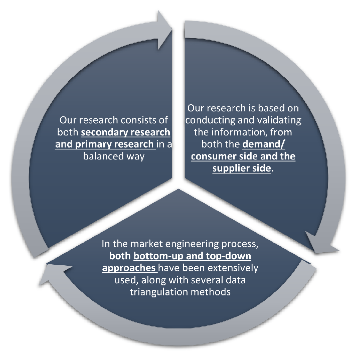
MarketGenics leverages a dedicated industry panel of experts and a comprehensive suite of paid databases to effectively collect, consolidate, and analyze market intelligence.
Our approach has consistently proven to be reliable and effective in generating accurate market insights, identifying key industry trends, and uncovering emerging business opportunities.
Through both primary and secondary research, we capture and analyze critical company-level data such as manufacturing footprints, including technical centers, R&D facilities, sales offices, and headquarters.
Our expert panel further enhances our ability to estimate market size for specific brands based on validated field-level intelligence.
Our data mining techniques incorporate both parametric and non-parametric methods, allowing for structured data collection, sorting, processing, and cleaning.
Demand projections are derived from large-scale data sets analyzed through proprietary algorithms, culminating in robust and reliable market sizing.
Research Approach
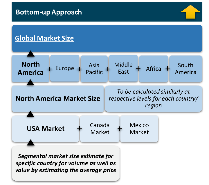
The bottom-up approach builds market estimates by starting with the smallest addressable market units and systematically aggregating them to create comprehensive market size projections.
This method begins with specific, granular data points and builds upward to create the complete market landscape.
Customer Analysis → Segmental Analysis → Geographical Analysis
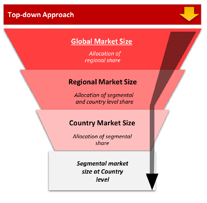
The top-down approach starts with the broadest possible market data and systematically narrows it down through a series of filters and assumptions to arrive at specific market segments or opportunities.
This method begins with the big picture and works downward to increasingly specific market slices.
TAM → SAM → SOM
Research Methods
Desk / Secondary Research
While analysing the market, we extensively study secondary sources, directories, and databases to identify and collect information useful for this technical, market-oriented, and commercial report. Secondary sources that we utilize are not only the public sources, but it is a combination of Open Source, Associations, Paid Databases, MG Repository & Knowledgebase, and others.
- Company websites, annual reports, financial reports, broker reports, and investor presentations
- National government documents, statistical databases and reports
- News articles, press releases and web-casts specific to the companies operating in the market, Magazines, reports, and others
- We gather information from commercial data sources for deriving company specific data such as segmental revenue, share for geography, product revenue, and others
- Internal and external proprietary databases (industry-specific), relevant patent, and regulatory databases
- Governing Bodies, Government Organizations
- Relevant Authorities, Country-specific Associations for Industries
We also employ the model mapping approach to estimate the product level market data through the players' product portfolio
Primary Research
Primary research/ interviews is vital in analyzing the market. Most of the cases involves paid primary interviews. Primary sources include primary interviews through e-mail interactions, telephonic interviews, surveys as well as face-to-face interviews with the different stakeholders across the value chain including several industry experts.
| Type of Respondents | Number of Primaries |
|---|---|
| Tier 2/3 Suppliers | ~20 |
| Tier 1 Suppliers | ~25 |
| End-users | ~25 |
| Industry Expert/ Panel/ Consultant | ~30 |
| Total | ~100 |
MG Knowledgebase
• Repository of industry blog, newsletter and case studies
• Online platform covering detailed market reports, and company profiles
Forecasting Factors and Models
Forecasting Factors
- Historical Trends – Past market patterns, cycles, and major events that shaped how markets behave over time. Understanding past trends helps predict future behavior.
- Industry Factors – Specific characteristics of the industry like structure, regulations, and innovation cycles that affect market dynamics.
- Macroeconomic Factors – Economic conditions like GDP growth, inflation, and employment rates that affect how much money people have to spend.
- Demographic Factors – Population characteristics like age, income, and location that determine who can buy your product.
- Technology Factors – How quickly people adopt new technology and how much technology infrastructure exists.
- Regulatory Factors – Government rules, laws, and policies that can help or restrict market growth.
- Competitive Factors – Analyzing competition structure such as degree of competition and bargaining power of buyers and suppliers.
Forecasting Models / Techniques
Multiple Regression Analysis
- Identify and quantify factors that drive market changes
- Statistical modeling to establish relationships between market drivers and outcomes
Time Series Analysis – Seasonal Patterns
- Understand regular cyclical patterns in market demand
- Advanced statistical techniques to separate trend, seasonal, and irregular components
Time Series Analysis – Trend Analysis
- Identify underlying market growth patterns and momentum
- Statistical analysis of historical data to project future trends
Expert Opinion – Expert Interviews
- Gather deep industry insights and contextual understanding
- In-depth interviews with key industry stakeholders
Multi-Scenario Development
- Prepare for uncertainty by modeling different possible futures
- Creating optimistic, pessimistic, and most likely scenarios
Time Series Analysis – Moving Averages
- Sophisticated forecasting for complex time series data
- Auto-regressive integrated moving average models with seasonal components
Econometric Models
- Apply economic theory to market forecasting
- Sophisticated economic models that account for market interactions
Expert Opinion – Delphi Method
- Harness collective wisdom of industry experts
- Structured, multi-round expert consultation process
Monte Carlo Simulation
- Quantify uncertainty and probability distributions
- Thousands of simulations with varying input parameters
Research Analysis
Our research framework is built upon the fundamental principle of validating market intelligence from both demand and supply perspectives. This dual-sided approach ensures comprehensive market understanding and reduces the risk of single-source bias.
Demand-Side Analysis: We understand end-user/application behavior, preferences, and market needs along with the penetration of the product for specific application.
Supply-Side Analysis: We estimate overall market revenue, analyze the segmental share along with industry capacity, competitive landscape, and market structure.
Validation & Evaluation
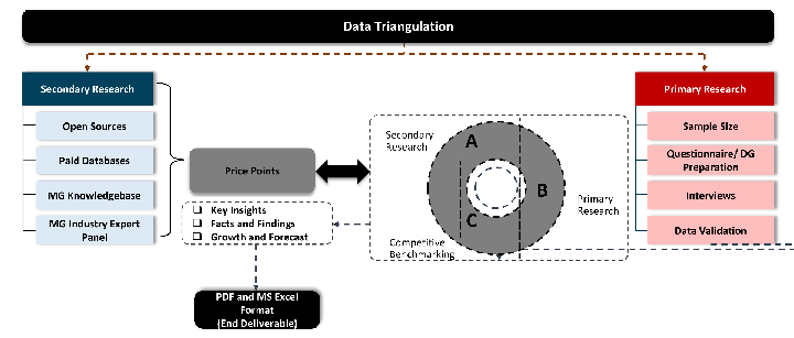
Data triangulation is a validation technique that uses multiple methods, sources, or perspectives to examine the same research question, thereby increasing the credibility and reliability of research findings. In market research, triangulation serves as a quality assurance mechanism that helps identify and minimize bias, validate assumptions, and ensure accuracy in market estimates.
- Data Source Triangulation – Using multiple data sources to examine the same phenomenon
- Methodological Triangulation – Using multiple research methods to study the same research question
- Investigator Triangulation – Using multiple researchers or analysts to examine the same data
- Theoretical Triangulation – Using multiple theoretical perspectives to interpret the same data
Custom Market Research Services
We will customise the research for you, in case the report listed above does not meet your requirements.
Get 10% Free Customisation